Phipps Stories

#bioPGH Blog: The Snow was a No-Go in 2023
 A resource of Biophilia: Pittsburgh, #bioPGH is a weekly blog and social media series that aims to encourage both children and adults to reconnect with nature and enjoy what each of our distinctive seasons has to offer.
I’m not complaining that I didn’t have to shovel my driveway, but I might be the tiniest bit disappointed that I didn’t get to throw a snowball or dress like Elsa and sing loudly in my backyard. Now that we are in 2024, it can be official: in 2023, Pittsburgh received the second-lowest snowfall on record. Throughout the year, we only received a total of 13.1 inches — second only to 1998’s 10.9 inches of snow. Given the warm temperatures we saw the last few weeks of December, it isn’t terribly surprising, but as you have also probably already heard, we are in an El Niño year, which is playing a role as well. What is El Niño and how does the Pacific Ocean play a role in Pennsylvania weather? Pull up a beach chair, and let’s do some exploring!
El Niño and La Niña
El Niño is a cyclical climate phenomenon that impacts both weather and the ocean. The trade winds of the Pacific normally push warm surface waters from east to west, which allows colder water to upwell to the surface. During an El Nino, though, the trade winds weaken and aren’t able to push warm waters in their usual direction. Thus, the cold waters that normally come to the surface stay in the deep ocean depths, and the surface of the Pacific stays warmer. This allows the Pacific jet stream to shift further south and east, which in turn changes weather patterns across North America. For us in the Northeast, that usually results in warmer, drier conditions than normal.
On the flipside, La Niña is essentially the opposite. During La Niña years, the trade winds are more powerful than usual, which pushes warm waters west and allows more cold waters to continually rise up to the surface. Thus, Pacific waters along our western coast are much colder, and the Pacific jet stream shifts north – bringing warmer and sometimes wetter conditions our way.
The big question is what causes El Niño and La Niña? The natural reasons behind it aren’t certain, but the oscillation between El Niño and La Niña years, fittingly called the El Niño Southern Oscillation (ENSO), is a natural, cyclical phenomenon — a fancy way of saying it’s just something that happens. Each El Niño and La Niña event can last from a few months to a few years, but the reasons behind why there is a natural fluctuation aren’t completely certain. We just know the impacts!
ENSO and Climate Change
If we look back at our year, there is no doubt that we can thank El Niño for the lack of snow, at least in part; but that doesn’t eliminate the possible involvement of climate change. We know climate change heightens weather extremes and variability, and ENSO is no different. Since 1960, ENSO events have caused greater average temperature swings in the Pacific Ocean than in the decades before 1960, which in turn has an effect on weather patterns and the jet stream. And yet even La Niña years haven’t quite kept pace with climate change; even with three La Niña years in a row, which should have had a net cooling effect globally, 2022 still managed to be one of the hottest years on record (5th warmest since the 1880s).
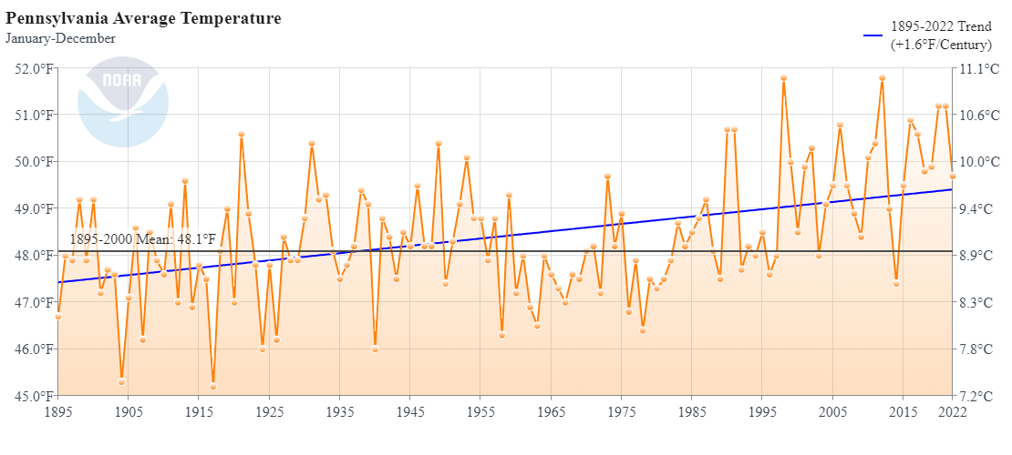
We can also note that annual average Pennsylvania temperatures certainly show variation from year to year, which would expect, the long-term trend over the past century has been an increase in temperature.

NOAA Climate at a Glance Tool
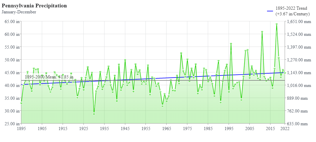
And in spite of ENSO impacts on precipitation, Pennsylvania is continuing to trend warmer over the past century:

NOAA Climate at a Glance Tool
What does this mean for the rest of the year? Will we see more snow? (Ironically, it is snowing as I write this.) ENSO events are difficult to predict, but for now, El Niño seems on track to continue at least through April, which means little snow for us this winter. Admittedly, the lack of ice makes it easier for us all to go outdoors, so let’s at least take advantage of that while we can!
Resources
Graphs all created here: NOAA National Centers for Environmental information, Climate at a Glance: Statewide Time Series, published December 2023, retrieved on January 3, 2024 from https://www.ncei.noaa.gov/access/monitoring/climate-at-a-glance/statewide/time-series
NOAA “What are El Niño and La Niña?”
Image credits: Cover, Flickr User BikesAndBooks, CC BY-NC-SA 2.0 DEED; header, Pexels, public domain.

