Blog

#bioPGH Blog: Following Spring Bird Migrations with Radar
 A resource of Biophilia: Pittsburgh, #bioPGH is a weekly blog and social media series that aims to encourage both children and adults to reconnect with nature and enjoy what each of our distinctive seasons has to offer.
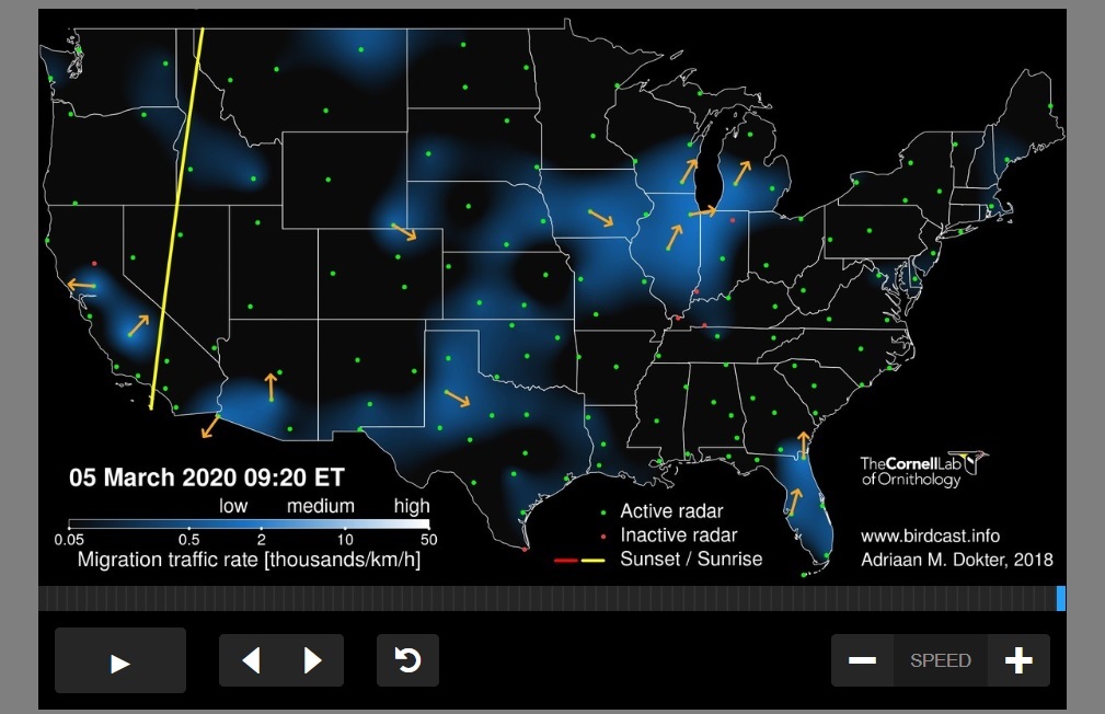
Looking at a colorful weather map doesn’t seem like the most intuitive way to look for birds, but it is if you’re looking at BirdCast! This project from Cornell University Lab of Ornithology monitors bird migration in real time using radar. Virtually the same radar technology that provides the information behind our rainstorm maps can also be used track the density of bird flocks as they migrate. And since spring bird migrations are underway, migration radar maps are practically glowing right now! We can learn quite a lot from these maps, even beyond counting the days until we have the spring arrivals at our bird feeders. Let’s explore!
First of all, how does radar actually work? It’s almost like a bat using echolocation — bats send out a vocalization that travels into the world around them, those sound waves bounce off objects and then come back to the bat. The bat can then create an “image” of their surroundings based on the returning sound waves. Radar does the same thing, but instead of emitting sound, radar systems send out electromagnetic waves into a target area. The waves will bounce off of different objects and some of the waves will return to the radar’s receiver to help create an “image” of that area. For a weather system, the waves bounce off of precipitation and help create an image of storms and weather conditions. BirdCast technology specifically looks at the radar signals from birds, which is tricky and requires a suite of algorithms plus human quality control and monitoring (read more about how the system filters biological and non-biological signals here.)
The BirdCast team’s use of radar can help us understand migration in ways that are difficult to otherwise study. Since most birds migrate at night, it can be hard to follow their activity, and the data from years of monitoring weather radar for birds have resulted in a number of important studies. Most recently, the team from BirdCast published a study that notes how the timing of migration over the last 24 years has shifted because of climate change. They have also noted how birds respond to the bright lights of cities during migration, and a BirdCast team member was an author on last year’s major study that looked at North American bird declines.
The fun part of BirdCast for all of us, though, is what the name implies — instead of a “weather forecast” we can get the “birdcast,” the prediction of when bird migrations will be heaviest and when weather conditions will be optimal to see them! If you’re interested in checking out when birds will be going by your favorite birding spot, check out Cornell’s detailed breakdown of their maps and keep an eye on BirdCast for when the prediction models go live any day now (as of publication time, only the live migration maps (below) were active, rather than the birding forecast.)

Connecting to the Outdoors Tips: Besides checking when might be a good evening to listen outdoors for overhead travelling flocks, you can also look at previous years’ of migration on the Live Migration Maps page and compare it to this. What month seems to have the most activity? What time of day does migration seem to peek?
Continue the Conversation: Share your nature discoveries with our community by posting to Twitter and Instagram with hashtag #bioPGH, and R.S.V.P. to attend our next Biophilia: Pittsburgh meeting.
Resources
NWS - How Does Doppler Radar Work?
All About Birds - Here's How to Use the Migration Forecast Tools from BirdCast
Images: Header, Tony Hisgett CC-BY-2.0; cover, BirdCast, image used with permission

